Polar Cyclone on Mars
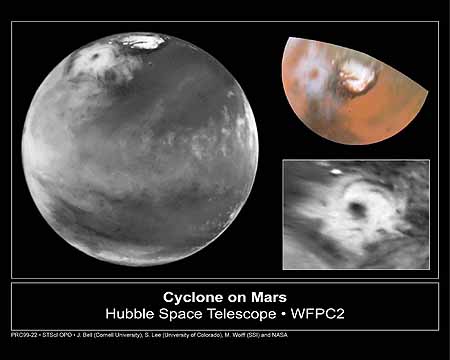 [left]: Here is the discovery image of the Martian polar storm as
seen in blue light (410 nm). The storm is located near 65 deg. N latitude
and 85 deg. W longitude, and is more than 1000 miles (1600 km) across.
The residual north polar water ice cap is at the top of the image. A belt
of clouds like that seen in previous telescopic observations during this
Martian season can also be seen in the planet's equatorial regions and
northern mid-latitudes, as well as in the southern polar regions. The volcano
Ascraeus Mons can be seen as a dark spot poking above the cloud deck near
the western (morning) limb. This extinct volcano towers nearly 16 miles
(25 km) above the surrounding plains and is about 250 miles (400 km) across.
[left]: Here is the discovery image of the Martian polar storm as
seen in blue light (410 nm). The storm is located near 65 deg. N latitude
and 85 deg. W longitude, and is more than 1000 miles (1600 km) across.
The residual north polar water ice cap is at the top of the image. A belt
of clouds like that seen in previous telescopic observations during this
Martian season can also be seen in the planet's equatorial regions and
northern mid-latitudes, as well as in the southern polar regions. The volcano
Ascraeus Mons can be seen as a dark spot poking above the cloud deck near
the western (morning) limb. This extinct volcano towers nearly 16 miles
(25 km) above the surrounding plains and is about 250 miles (400 km) across.
[upper right]: This is a color polar view of the north polar
region, showing the location of the storm relative to the classical bright
and dark features in this area. The color composite data (410, 502, and
673 nm) indicate that the storm is fairly dust-free and therefore likely
composed mostly of water ice clouds. The bright surface region beneath
the eye of the storm can be seen clearly. This map covers the region north
of 45 degrees latitude and is oriented with 0 degrees longitude at the
bottom.
[lower right]: This is an enhanced orthographic view of the storm
centered on 65 deg. N latitude, 85 deg. W longitude. The image has been
processed to bring out additional detail in the storm's spiral cloud structures.
The pictures were taken on April 27, 1999 with the NASA Hubble Space
Telescope's Wide Field and Planetary Camera 2. Credit: Jim Bell (Cornell
U.), Steve Lee (U. Colorado), Mike Wolff (SSI), and NASA